In Nice, “Riquier” is now primarily known as the name of a district: Riquier is located northeast of the old port (Port Lympia) and underwent rapid development in the 19th century, particularly with the construction of the railway and industrialization.
The name goes back to a family or landowners who owned land there in the 17th and 18th centuries. As with many districts in southern France, the name of a dominant owner was retained as the place name.
The Riquier district later became: an important transport hub (Nice-Riquier railway station), a working-class neighborhood in the 19th century and today a mixed residential and commercial district.
The family was therefore less “politically powerful” in the sense of the great noble houses, but rather part of the local notables who wielded influence through land ownership and municipal offices.
Connections to Èze
Èze, the medieval village between Nice and Monaco, was dominated by agriculture for centuries. Many families from Nice owned olive groves, terraced fields, or estates there.
Here, too, the name Riquier appears in archival documents: as a landowner, in church registers, in connection with agricultural leases.
Its significance therefore lay in the economic network between the city (Nice) and the hinterland (Èze).
Historical context: Nice between Savoy and France
It should not be forgotten that until 1860, Nice did not belong to France, but to the Kingdom of Sardinia-Piedmont under the House of Savoy. It was only through the Treaty of Turin in 1860 that Nice became French.
Many long-established families—including, presumably, the Riquiers—were caught up in this political transition between: Italian-Ligurian culture, Savoyard administration, and French integration.
The name “Riquier” itself probably has Provençal-Occitan roots and could go back to the medieval first name “Riquer” (equivalent to Richard).
Symbolic significance today
Today, “Riquier” in Nice stands less for a single historical figure than for: an urban identity area, the memory of pre-industrial ownership structures, the transformation from land ownership to a modern city.
In Èze, the name remains more of an archival presence.
Conclusion
The Riquier family was not a European noble dynasty, but part of the local elite, with economic significance due to land ownership, and indirect influence on the urban development of Nice.
Their name did not endure through politics, but through topography.
This scenic hike on the Côte d’Azur combines history, nature and spectacular sea views. Over a relatively short distance, you will encounter Mediterranean vegetation, military architecture and descend into one of the most beautiful bays in the region.
Start: Col de Villefranche
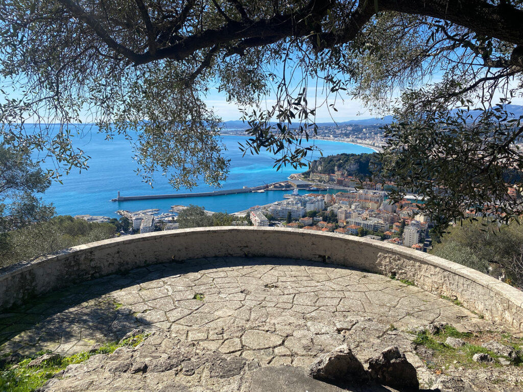
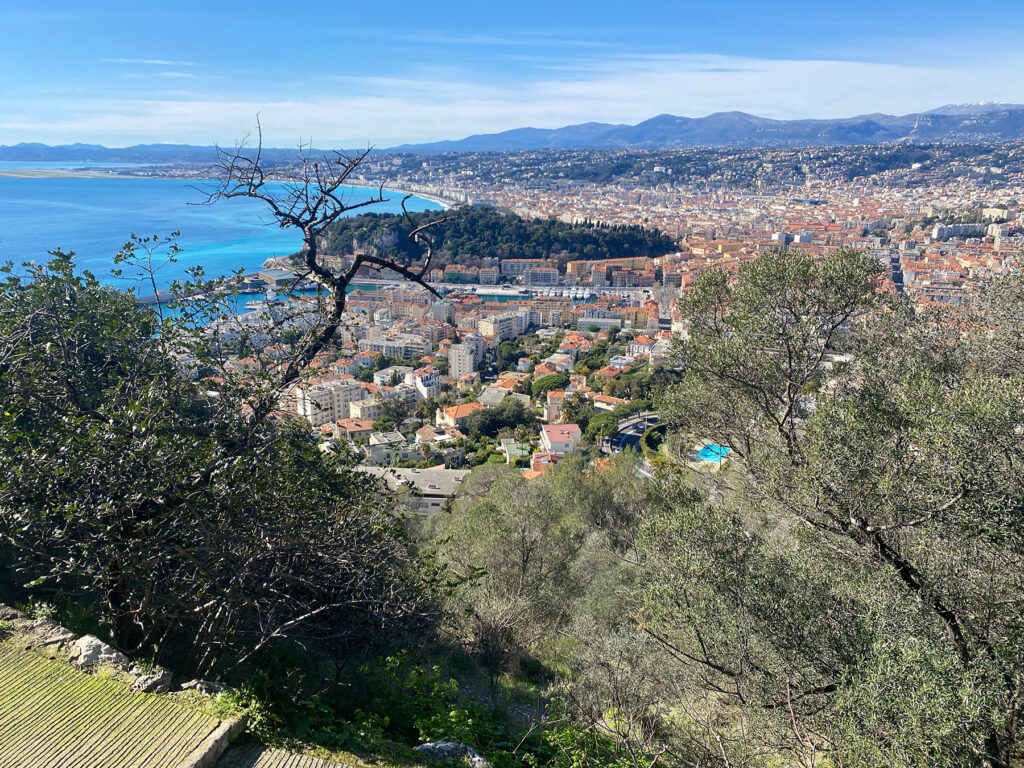
The Col de Villefranche is located at an altitude of about 200 metres between Nice and Villefranche-sur-Mer. From here, several well-signposted paths lead towards Mont Alban. After just a few minutes, the view opens up to the deep blue Rade de Villefranche and the Cap Ferrat peninsula.
The trail initially runs through a sparse pine forest. The scent of Aleppo pines, rosemary and thyme accompanies you – typical of the garrigue vegetation of the region. The incline is moderate and easily manageable.
Stage 1: Ascent to the fort
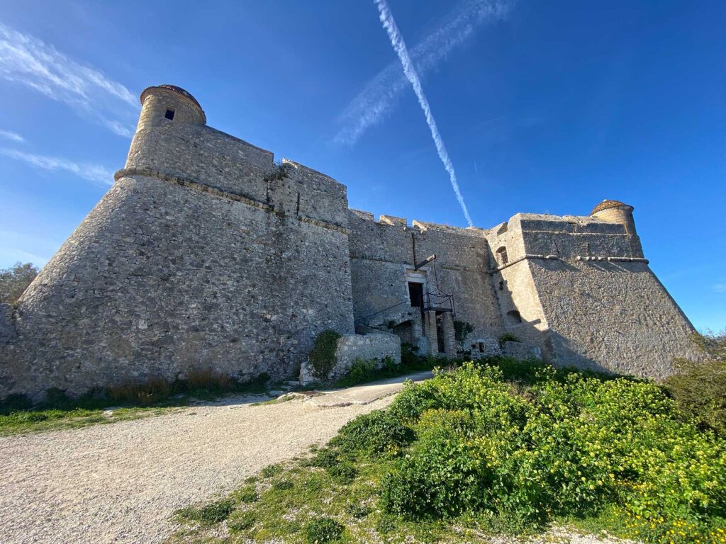
After about 20–30 minutes, you will reach the Fort du Mont Alban, a 16th-century fortress. The massive structure is perched at an altitude of around 220 metres and offers one of the most beautiful panoramas of the Côte d’Azur:
View westwards over the Bay of Nice
View eastwards over the roadstead of Villefranche
On a clear day: the snow-capped Maritime Alps in the hinterland
It is definitely worth taking a break here. Small paths lead to various vantage points around the fort.
Stage 2: Descent towards Villefranche
From the fort, take the path towards Villefranche-sur-Mer. The path winds its way downhill through Mediterranean vegetation. Again and again, new perspectives of the bay open up – the play of colours between ochre facades, turquoise water and green hills is typical of the region.
The descent takes about 40–60 minutes, depending on your pace and photo stops. The path is rocky in places, so sturdy shoes are recommended.
Destination: Villefranche-sur-Mer
Once you reach the bottom, you will arrive at the old town of Villefranche-sur-Mer with its narrow streets and pastel-coloured houses. The historic Saint-Elme citadel, which also refers to the military importance of the region, is particularly worth seeing.
You can relax at the harbour or on the beach at the end of your hike – perhaps with a coffee or a swim in the sea.
Practical information
Duration: approx. 1.5–2.5 hours (without long breaks)
Difficulty: easy to moderate
Elevation difference: approx. 200 metres
Best time: spring and autumn (summer can be very hot)
Equipment: water, sunscreen, sturdy shoes
Conclusion
The hike from Col de Villefranche via Fort Vauban (Mont Alban) to Villefranche-sur-Mer is ideal for anyone looking for a short but impressive tour. It combines nature with history and offers some of the most beautiful views on the French Mediterranean coast.
Places Hike from Col de Villefranche via Fort du Mont Alban to Villefranche-sur-Mer with a tour of the Citadelle Saint-Elme
This varied tour combines nature, spectacular views and impressive military architecture – an ideal day trip on the Côte d’Azur.
Start at Col de Villefranche
Col de Villefranche is located at an altitude of about 200 metres between Nice and Villefranche-sur-Mer. Several paths lead from the car park or the road towards Mont Alban. After just a few minutes, the first views of the deeply indented bay of Villefranche and Cap Ferrat open up.
The path climbs gently and leads through a sparse pine forest. Mediterranean plants such as rosemary, thyme and dwarf palms line the path. The climb is moderate and easy to walk.
Walking time to the fort: approx. 20–30 minutes
Fort du Mont Alban viewpoint (Fort Vauban)
At an altitude of around 220 metres, you will reach Fort du Mont Alban, a 16th-century fortress. The complex was built under Savoyard rule and served to control the strategically important coastline.
From up here, you can enjoy a spectacular panorama:
To the west, the Baie des Anges and Nice
To the east, the Rade de Villefranche
In the background, the Maritime Alps
The view is one of the most beautiful in the entire region. It is worth taking a longer break to enjoy the different perspectives around the complex.
Descent to Villefranche-sur-Mer
From the fort, the path winds downhill towards Villefranche. The path is partly rocky but easy to follow. During the descent, wooded areas alternate with open viewpoints that offer ever-changing perspectives of the sea.
As you get closer to the village, the ochre-coloured houses and small harbour of Villefranche-sur-Mer come into view. The descent takes about 45-60 minutes.
Destination: The Citadelle Saint-Elme in Villefranche
Once you arrive at the harbour, you will reach the impressive Citadelle Saint-Elme. Built in the 16th century, this fortress served to secure the bay and was part of a comprehensive defence system for the region.
Today, the citadel is the cultural centre of the city and houses several museums and exhibitions:
Museums and galleries in the citadel
Musée Volti – sculptures by the artist Antoniucci Volti
Musée Goetz-Boumeester – works of modern art
Collections on the history of the city – historical documents and models
The inner courtyards, vaulted corridors and bastions can be explored freely. The thick walls and the view of the bay from the bastions are particularly impressive.
Visiting time: approx. 1–1.5 hours
Practical information
Total duration (including visit): approx. 3–4 hours
Elevation difference: approx. 200 metres
Difficulty: easy to moderate
Equipment: sturdy shoes, water, sun protection
Best season: spring and autumn (very hot in summer)
Conclusion
This hike impressively combines nature, history and culture. From the panorama at Fort du Mont Alban to the atmospheric tour of the Citadelle Saint-Elme, you will experience the strategic importance of the bay of Villefranche up close. The alternation between Mediterranean landscape and historical architecture makes this tour one of the most beautiful half-day excursions on the Côte d’Azur.
Fort du Mont Alban
High above the Bay of Nice, between Nice and Villefranche-sur-Mer, stands the Fort du Mont Alban – usually referred to simply as ‘Fort Alban’. This striking 16th-century fortress is not only an impressive example of early modern military architecture, but also a landmark that shapes the identity of the Côte d’Azur region.
Historical background
The fort was built in the 16th century under the rule of Emmanuel Philibert. At that time, Nice did not yet belong to France, but to the Duchy of Savoy. The aim of the construction was to secure the strategically important coastline against attacks, especially from the sea. Its exposed location at an altitude of around 220 metres allowed a wide view over the Bay of Nice and the port of Villefranche.
The massive, star-shaped structure with its thick walls and bastions was in line with the most modern defence principles of its time. Together with the citadel of Villefranche, the fort formed an effective defence system that could control both sea and land attacks.
Strategic importance
Its location between present-day Nice and Villefranche-sur-Mer made the fort a key point for regional security. From here, troops could detect movements along the coast at an early stage. Especially in an era when Mediterranean ports were of great importance for trade and the military, control of the sea routes was a decisive factor of power.
The fort retained its military relevance in later centuries. It continued to be used and adapted during various conflicts. Its solid construction has contributed to its good state of preservation to this day.
Significance for the surrounding area
Today, the fort no longer fulfils a military function, but is an important cultural and tourist attraction. It symbolises the region’s turbulent history – from Savoyard rule to integration into France and the modern development of the Côte d’Azur.
The fort is a popular destination for the inhabitants of Nice. The surrounding park offers walking trails with spectacular panoramic views of the Mediterranean, the foothills of the Alps and the coastal towns. Especially at sunset, the viewpoint is one of the most beautiful in the region.
The fort also contributes to the local identity: it is a reminder of the time when Nice was not yet French and illustrates the city’s historical role as a border and port city between different political powers.
Architecture and current condition
The compact, rectangular structure with its bastions is an example of Renaissance military architecture. Although the interior of the fort is not permanently open to the public, the complex can be viewed from the outside. The massive stone walls still convey an impression of the strategic importance of the building.
Conclusion
Fort Alban is much more than an old fortress. It is a historical testimony to power politics in the Mediterranean region, a symbol of regional identity and a viewpoint of exceptional beauty. Its presence above the Bay of Nice connects the past and the present – and highlights how closely history, landscape and urban development are intertwined on the Côte d’Azur.
in german:
Diese aussichtsreiche Wanderung an der Côte d’Azur verbindet Geschichte, Natur und spektakuläre Meerblicke. Auf relativ kurzer Strecke erlebst du mediterrane Vegetation, militärische Architektur und den Abstieg in eine der schönsten Buchten der Region.
Start: Col de Villefranche
Der Col de Villefranche liegt auf etwa 200 Metern Höhe zwischen Nizza und Villefranche-sur-Mer. Von hier aus führen mehrere gut ausgeschilderte Wege in Richtung Mont Alban. Schon nach wenigen Minuten öffnet sich der Blick auf die tiefblaue Rade de Villefranche und die Halbinsel Cap Ferrat.
Der Weg verläuft zunächst durch lichten Pinienwald. Der Duft von Aleppokiefern, Rosmarin und Thymian begleitet dich – typisch für die Garrigue-Vegetation der Region. Die Steigung ist moderat und gut machbar.
Etappe 1: Aufstieg zum Fort
Nach etwa 20–30 Minuten erreichst du das Fort du Mont Alban, eine Festung aus dem 16. Jahrhundert. Die massive Anlage thront auf rund 220 Metern Höhe und bietet eines der schönsten Panoramen der Côte d’Azur:
Blick westwärts über die Bucht von Nizza
Blick ostwärts über die Reede von Villefranche
Bei klarer Sicht: die schneebedeckten Seealpen im Hinterland
Eine Pause lohnt sich hier unbedingt. Rund um das Fort führen kleine Wege zu verschiedenen Aussichtspunkten.
Etappe 2: Abstieg Richtung Villefranche
Vom Fort aus nimmst du den Weg in Richtung Villefranche-sur-Mer. Der Pfad schlängelt sich in Serpentinen bergab durch mediterrane Vegetation. Immer wieder eröffnen sich neue Perspektiven auf die Bucht – das Farbspiel zwischen Ockerfassaden, türkisfarbenem Wasser und grünen Hügeln ist typisch für die Region.
Der Abstieg dauert etwa 40–60 Minuten, je nach Tempo und Fotostopps. Der Weg ist stellenweise steinig, daher sind feste Schuhe empfehlenswert.
Ziel: Villefranche-sur-Mer
Unten angekommen erreichst du die Altstadt von Villefranche-sur-Mer mit ihren engen Gassen und pastellfarbenen Häusern. Besonders sehenswert ist die historische Zitadelle Saint-Elme, die ebenfalls auf die militärische Bedeutung der Region verweist.
Am Hafen oder am Strand kannst du die Wanderung entspannt ausklingen lassen – vielleicht mit einem Kaffee oder einem Bad im Meer.
Praktische Hinweise
Dauer: ca. 1,5–2,5 Stunden (ohne lange Pausen)
Schwierigkeit: leicht bis mittel
Höhenunterschied: etwa 200 Meter
Beste Zeit: Frühjahr und Herbst (Sommer kann sehr heiß sein)
Ausrüstung: Wasser, Sonnenschutz, feste Schuhe
Fazit
Die Wanderung vom Col de Villefranche über das Fort Vauban (Mont Alban) nach Villefranche-sur-Mer ist ideal für alle, die eine kurze, aber eindrucksvolle Tour suchen. Sie verbindet Naturerlebnis mit Geschichte und bietet einige der schönsten Ausblicke an der französischen Mittelmeerküste.
Beschreibe mir bitte eine Wanderung vom Col de Villefranche über das Fort Vauban nach Villefranche und abschließender Besichtung des Fort von Villefranche mit Besichtigung der Galerien und Museen im Fort.
Wanderung vom Col de Villefranche über das Fort du Mont Alban nach Villefranche-sur-Mer mit Besichtigung der Citadelle Saint-Elme
Diese abwechslungsreiche Tour verbindet Natur, spektakuläre Ausblicke und eindrucksvolle Militärarchitektur – ein idealer Tagesausflug an der Côte d’Azur.
1. Start am Col de Villefranche
Der Col de Villefranche liegt auf etwa 200 Metern Höhe zwischen Nizza und Villefranche-sur-Mer. Vom Parkplatz bzw. der Straße aus führen mehrere Wege in Richtung Mont Alban. Schon nach wenigen Minuten eröffnen sich erste Blicke auf die tief eingeschnittene Bucht von Villefranche und das Cap Ferrat.
Der Weg steigt sanft an und führt durch lichten Pinienwald. Mediterrane Pflanzen wie Rosmarin, Thymian und Zwergpalmen säumen den Pfad. Der Anstieg ist moderat und gut begehbar.
Gehzeit bis zum Fort: ca. 20–30 Minuten
2. Aussichtspunkt Fort du Mont Alban (Fort Vauban)
Auf rund 220 Metern Höhe erreichst du das Fort du Mont Alban, eine Festung aus dem 16. Jahrhundert. Die Anlage wurde unter savoyischer Herrschaft erbaut und diente der Kontrolle der strategisch wichtigen Küste.
Von hier oben bietet sich ein spektakuläres Panorama:
Westwärts die Baie des Anges und Nizza
Ostwärts die Rade de Villefranche
Im Hintergrund die Seealpen
Die Aussicht gehört zu den schönsten der gesamten Region. Eine längere Pause lohnt sich, um die verschiedenen Blickwinkel rund um die Anlage zu genießen.
3. Abstieg nach Villefranche-sur-Mer
Vom Fort führt der Weg in Serpentinen bergab Richtung Villefranche. Der Pfad ist teils steinig, aber gut erkennbar. Während des Abstiegs wechseln sich Waldstücke mit offenen Aussichtspunkten ab, die immer neue Perspektiven auf das Meer eröffnen.
Mit zunehmender Nähe zum Ort erscheinen die ockerfarbenen Häuser und der kleine Hafen von Villefranche-sur-Mer. Der Abstieg dauert etwa 45–60 Minuten.
4. Ziel: Die Citadelle Saint-Elme in Villefranche
Am Hafen angekommen erreichst du die beeindruckende Citadelle Saint-Elme. Diese im 16. Jahrhundert errichtete Festung diente der Sicherung der Bucht und war Teil eines umfassenden Verteidigungssystems der Region.
Heute ist die Zitadelle kulturelles Zentrum der Stadt und beherbergt mehrere Museen und Ausstellungen:
Museen und Galerien in der Zitadelle
Musée Volti – Skulpturen des Künstlers Antoniucci Volti
Musée Goetz-Boumeester – Werke moderner Kunst
Sammlungen zur Stadtgeschichte – historische Dokumente und Modelle
Die Innenhöfe, Gewölbegänge und Bastionen können frei erkundet werden. Besonders eindrucksvoll sind die dicken Mauern und die Aussicht von den Bastionen auf die Bucht.
Besichtigungszeit: ca. 1–1,5 Stunden
5. Praktische Hinweise
Gesamtdauer (inkl. Besichtigung): ca. 3–4 Stunden
Höhenunterschied: ca. 200 Meter
Schwierigkeit: leicht bis mittel
Ausrüstung: feste Schuhe, Wasser, Sonnenschutz
Beste Jahreszeit: Frühjahr und Herbst (im Sommer sehr heiß)
Fazit
Diese Wanderung verbindet eindrucksvoll Natur, Geschichte und Kultur. Vom Panorama am Fort du Mont Alban bis zur atmosphärischen Besichtigung der Citadelle Saint-Elme erlebst du die strategische Bedeutung der Bucht von Villefranche aus nächster Nähe. Der Wechsel zwischen mediterraner Landschaft und historischer Architektur macht diese Tour zu einem der schönsten Halbtagesausflüge an der Côte d’Azur.
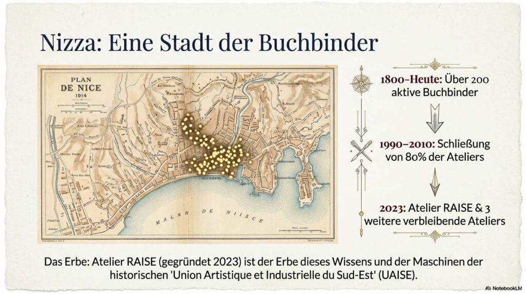
Das Atelier RAISE in Nizza, geführt von dem Experten Vincent Bottasso-Daideri, widmet sich der professionellen Buchbinderei und der Restaurierung historischer sowie moderner Werke. Die Quellen beschreiben ein breites Spektrum an Dienstleistungen, das von handwerklichen Fachkursen bis hin zur Gestaltung luxuriöser Künstlereditionen und humorvoller Kunstprojekte wie dem „Pass des Rosa Katzen-Landes“ reicht. Bottasso-Daideri ist zudem in der regionalen Kulturszene tief verwurzelt, unter anderem als Generalsekretär der Freunde des Kunstmuseums von Nizza und durch Kooperationen mit lokalen Künstlern wie Gérard Serée. Historische Rückblicke beleuchten die lange Tradition des Buchbinderhandwerks in der Region, während technische Erklärungen Einblicke in anspruchsvolle Verfahren wie die Vergoldung oder die Mosaik-Bindung geben. Das Atelier versteht sich somit als ein Zentrum für die Bewahrung des schriftlichen Kulturerbes und die Förderung zeitgenössischer Buchkunst.
We did this full-day train experience through the Alps from Nice, and it completely surprised us in the best way. We met early in the morning at the main train station, grabbed a quick coffee, and then boarded the mountain train that slowly climbed into the Alps. The ride itself was incredible, winding through narrow canyons, tunnels, and over high viaducts, with nonstop views of valleys, rivers, and tiny villages tucked into the mountains. Our guide shared stories and pointed out details along the way, which made the journey even more interesting and helped us understand what we were seeing instead of just passing through it.
Once we reached the Roya Valley, we started exploring a couple of medieval villages, including Saorge and Tende. Walking through the narrow stone streets, small squares, and quiet corners felt like stepping into another time. We visited old churches, took in sweeping mountain views, and even did a short hike that led to some really peaceful spots overlooking the valley. Lunch was simple and relaxed, with local food that tasted even better after a morning of walking and fresh mountain air. Everything was well-paced, and there was a nice balance between exploring, learning, and just enjoying the scenery.
What stood out most was how different this day felt compared to the busy coastal towns. It was calm, scenic, and refreshing, and the logistics were completely taken care of, which made it easy to just enjoy the experience. Planning this kind of route on our own with trains, buses, and village connections would have been complicated, so having a guide and a clear plan made a huge difference. If you want a break from the Riviera crowds and love scenic train rides, mountain views, and quiet villages, this is such a memorable way to spend a day.
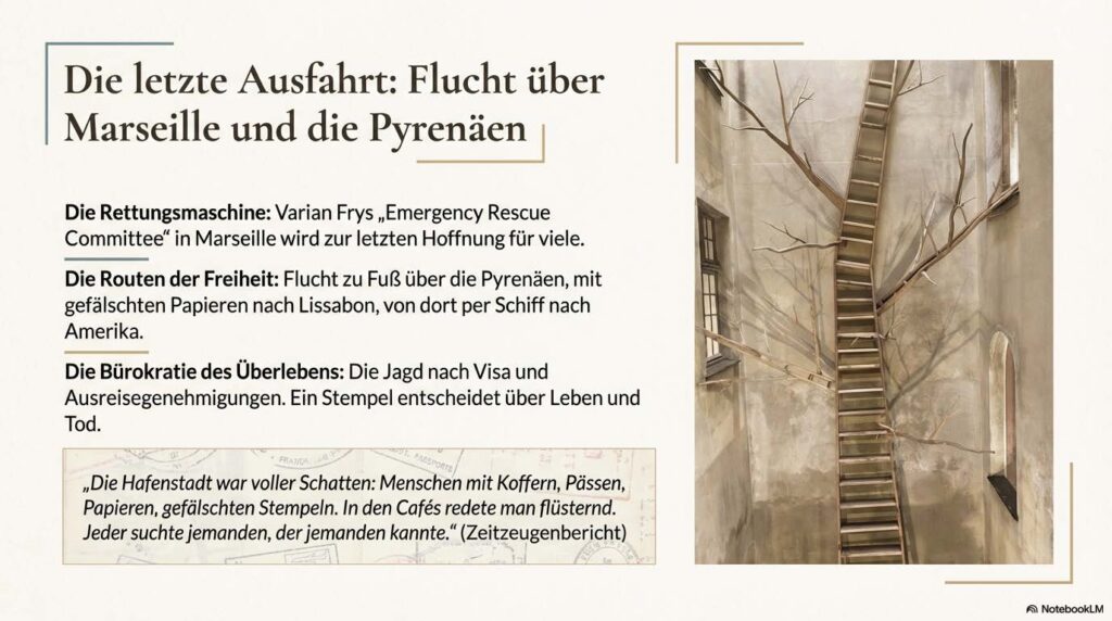
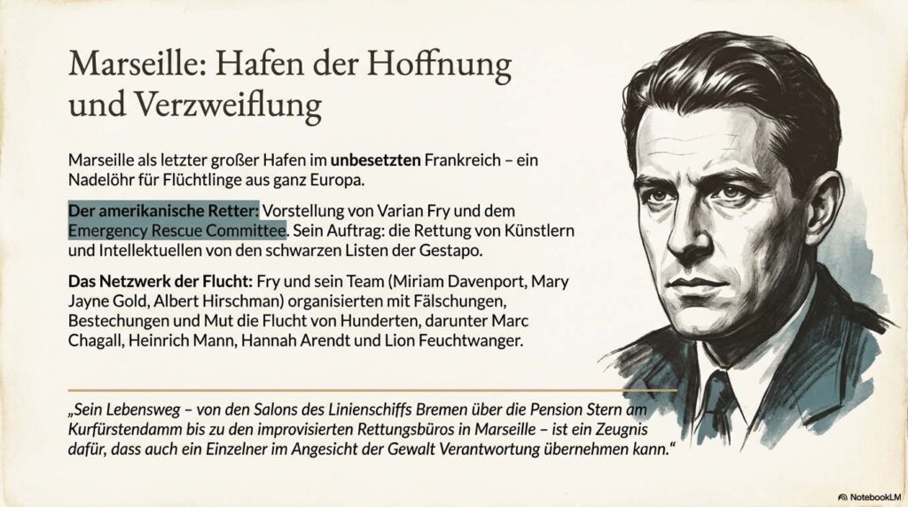
Podcast von Arcoplexus zum Buch “Deutsche Exilanten an der Côte d’Azur” von Klaus Kampe. Das Werk dokumentiert das bewegte Leben deutscher Exilanten an der Côte d’Azur während der 1930er Jahre. Im Fokus stehen Zufluchtsorte wie Sanary-sur-Mer und Nizza, wo bedeutende Intellektuelle wie Thomas Mann, Lion Feuchtwanger und Hannah Arendt versuchten, ihre kulturelle Identität gegen das NS-Regime zu verteidigen. Die Texte beleuchten zudem die mutigen Rettungsaktionen von Varian Fry in Marseille sowie die künstlerische Arbeit des Fotografen Walter Bondy. Neben literarischen Analysen und historischen Fakten fließen persönliche Anekdoten und fiktive Dialoge ein, die das Spannungsfeld zwischen mediterraner Idylle und existenzieller Bedrohung spürbar machen. Letztlich dient das Buch als Hommage an die schöpferische Kraft einer Generation, die trotz Verfolgung und Internierung an Humanismus und Freiheit festhielt. Es verbindet dabei die historische Spurensuche mit dem kollektiven Gedächtnis einer verlorenen Welt. Zum Buch:
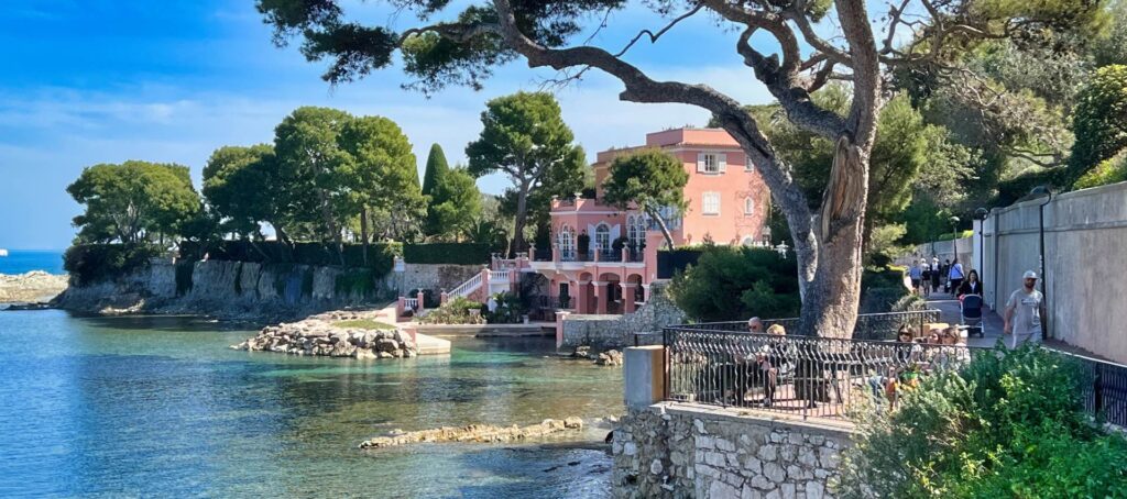
On the prestigious French Riviera, on the Saint-Jean-Cap-Ferrat peninsula, stands one of the most famous villa estates on the Côte d’Azur: the pink villa, now called La Fleur du Cap. This property is a fascinating example of late 19th-century luxury architecture, which over time has been home to a remarkable series of prominent residents and has become a setting for the social and cultural history of the Riviera.
Architecture and construction history
The villa was built in 1880 by Albert Bounin, the son of a Sardinian arms dealer and olive oil merchant from Nice. Bounin acquired several plots of land on the quiet headland of Cap Ferrat and had a picturesque estate built there, which he initially called L’Isoletta and which had a small private harbor. From the outset, the building captivated visitors with its location directly on the sea and its striking pink façade, which would later give it its name.
Later, his son Paul took over the estate, added an extra floor, and renamed the villa Lo Scoglietto (“the little rock”). During these early years, the house remained largely hidden from public view, but it soon became a notable destination for wealthy travelers on the Riviera.
Prominent residents in front of Niven
During the first decades of the 20th century, the villa changed owners and tenants several times:
In 1920, the Duchess of Marlborough, Consuelo Vanderbilt, one of the most prominent society figures of her time, lived there for a while.
In the 1950s, the villa was occupied by King Leopold III of Belgium shortly before his abdication.
The silent film and early sound film star Charlie Chaplin spent several weeks at the estate.
This series of famous guests shows how strongly the Riviera had become a refuge for aristocrats, movie stars, and wealthy travelers since the early 20th century—a trend that also had a strong influence on the image of the villa.
David Niven and the Riviera Era
Perhaps the most famous resident of the pink villa was British actor David Niven (1910–1983). Niven bought the villa in the late 1950s/early 1960s and made it his long-term home.
David Niven was one of the most charming and versatile actors of his generation. A Hollywood star, author, and former officer, he was considered an elegant gentleman with British charm. Niven was closely connected to the international celebrity scene on the Riviera: he was friends with Princess Grace Kelly and Prince Rainier of Monaco and was one of the well-known personalities who shaped the lifestyle of the Côte d’Azur in those years.
During this time, the pink villa was not only a private residence, but also a place for social gatherings. Niven also played a cinematic role as part of the estate: a scene from his film “Trail of the Pink Panther” (1982) was shot here — an ironic reference to the villa with its striking color and celebrity connections.
After his death in 1983, the small square in front of the villa was named Place David Niven — a lasting testament to the actor’s influence on local culture and the collective memory of Saint-Jean-Cap-Ferrat.
NAfterlife and restoration
Over the following decades, the property changed hands several times; since 1999, it has belonged to the parents of New Zealand billionaires Christopher and Richard Chandler, who had it extensively restored. Today, the villa is called La Fleur du Cap and is larger and better maintained than ever before — a monument to the glamorous era of the Riviera.
Conclusion
The pink villa in Cap Ferrat uniquely embodies the history of the Côte d’Azur: it is an expression of luxurious 19th-century architecture, a reflection of an aristocratic and cinematic society, and at the same time a place where the lives of prominent personalities such as David Niven have materialized. Its bright color and spectacular location above the sea make it a symbol of glamour, elegance, and the cultural appeal of the French Riviera to this day.