In Nice, “Riquier” is now primarily known as the name of a district: Riquier is located northeast of the old port (Port Lympia) and underwent rapid development in the 19th century, particularly with the construction of the railway and industrialization.
The name goes back to a family or landowners who owned land there in the 17th and 18th centuries. As with many districts in southern France, the name of a dominant owner was retained as the place name.
The Riquier district later became: an important transport hub (Nice-Riquier railway station), a working-class neighborhood in the 19th century and today a mixed residential and commercial district.
The family was therefore less “politically powerful” in the sense of the great noble houses, but rather part of the local notables who wielded influence through land ownership and municipal offices.
Connections to Èze
Èze, the medieval village between Nice and Monaco, was dominated by agriculture for centuries. Many families from Nice owned olive groves, terraced fields, or estates there.
Here, too, the name Riquier appears in archival documents: as a landowner, in church registers, in connection with agricultural leases.
Its significance therefore lay in the economic network between the city (Nice) and the hinterland (Èze).
Historical context: Nice between Savoy and France
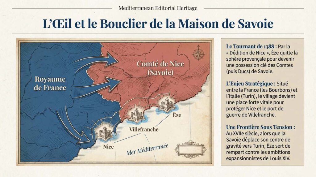
It should not be forgotten that until 1860, Nice did not belong to France, but to the Kingdom of Sardinia-Piedmont under the House of Savoy. It was only through the Treaty of Turin in 1860 that Nice became French.
Many long-established families—including, presumably, the Riquiers—were caught up in this political transition between: Italian-Ligurian culture, Savoyard administration, and French integration.
The name “Riquier” itself probably has Provençal-Occitan roots and could go back to the medieval first name “Riquer” (equivalent to Richard).
Symbolic significance today
Today, “Riquier” in Nice stands less for a single historical figure than for: an urban identity area, the memory of pre-industrial ownership structures, the transformation from land ownership to a modern city.
In Èze, the name remains more of an archival presence.
Conclusion
The Riquier family was not a European noble dynasty, but part of the local elite, with economic significance due to land ownership, and indirect influence on the urban development of Nice.
Their name did not endure through politics, but through topography.
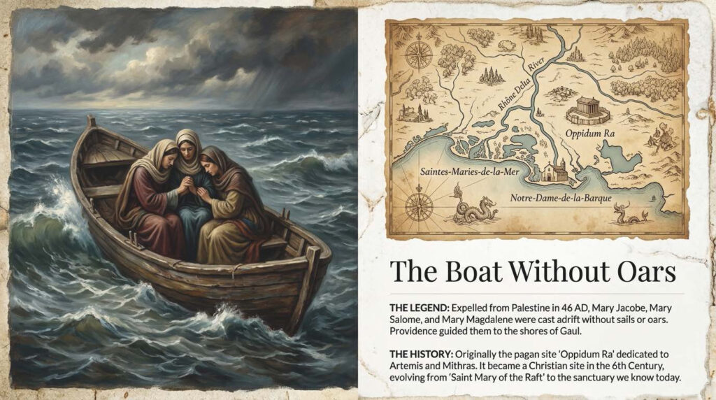
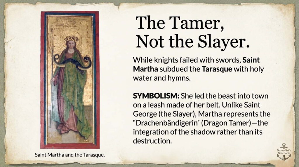
These sources offer an in-depth examination of Provençal folklore, which combines ancient myths, Christian legends, and the rugged nature of southern France. The focus is on stories about Saint Martha, who tamed the river monster Tarasque, and the arrival of the three Marys in the Camargue. The texts analyze how archaic symbols of female power and natural phenomena such as the Mistral wind were transformed by religious traditions. In addition to regional symbols of identity such as cicadas and lavender, darker aspects such as werewolf beliefs and witch legends are also examined. Overall, the documents show that these myths serve as cultural memory and continue to live on in vibrant customs and festivities to this day.
This scenic hike on the Côte d’Azur combines history, nature and spectacular sea views. Over a relatively short distance, you will encounter Mediterranean vegetation, military architecture and descend into one of the most beautiful bays in the region.
Start: Col de Villefranche
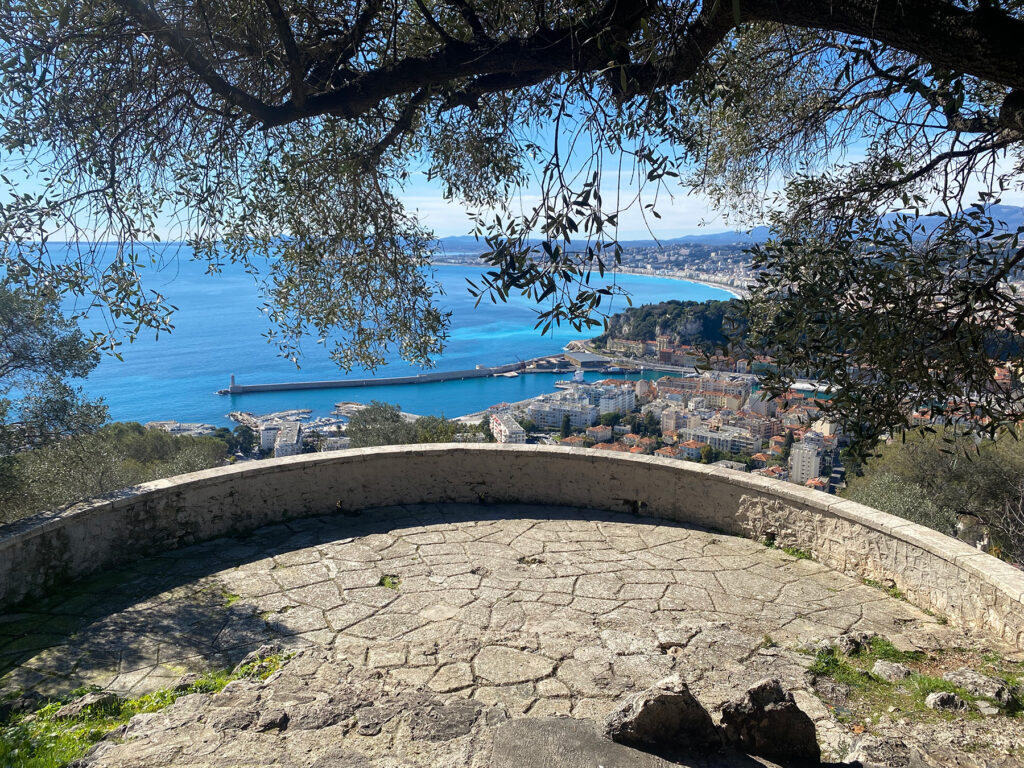
The Col de Villefranche is located at an altitude of about 200 metres between Nice and Villefranche-sur-Mer. From here, several well-signposted paths lead towards Mont Alban. After just a few minutes, the view opens up to the deep blue Rade de Villefranche and the Cap Ferrat peninsula.
The trail initially runs through a sparse pine forest. The scent of Aleppo pines, rosemary and thyme accompanies you – typical of the garrigue vegetation of the region. The incline is moderate and easily manageable.
Stage 1: Ascent to the fort
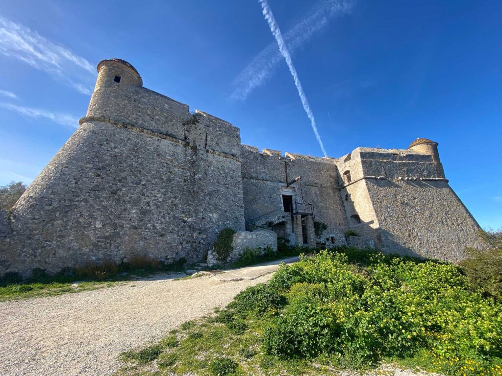
After about 20–30 minutes, you will reach the Fort du Mont Alban, a 16th-century fortress. The massive structure is perched at an altitude of around 220 metres and offers one of the most beautiful panoramas of the Côte d’Azur:
View westwards over the Bay of Nice
View eastwards over the roadstead of Villefranche
On a clear day: the snow-capped Maritime Alps in the hinterland
It is definitely worth taking a break here. Small paths lead to various vantage points around the fort.
Stage 2: Descent towards Villefranche
From the fort, take the path towards Villefranche-sur-Mer. The path winds its way downhill through Mediterranean vegetation. Again and again, new perspectives of the bay open up – the play of colours between ochre facades, turquoise water and green hills is typical of the region.
The descent takes about 40–60 minutes, depending on your pace and photo stops. The path is rocky in places, so sturdy shoes are recommended.
Destination: Villefranche-sur-Mer
Once you reach the bottom, you will arrive at the old town of Villefranche-sur-Mer with its narrow streets and pastel-coloured houses. The historic Saint-Elme citadel, which also refers to the military importance of the region, is particularly worth seeing.
You can relax at the harbour or on the beach at the end of your hike – perhaps with a coffee or a swim in the sea.
Practical information
Duration: approx. 1.5–2.5 hours (without long breaks)
Difficulty: easy to moderate
Elevation difference: approx. 200 metres
Best time: spring and autumn (summer can be very hot)
Equipment: water, sunscreen, sturdy shoes
Conclusion
The hike from Col de Villefranche via Fort Vauban (Mont Alban) to Villefranche-sur-Mer is ideal for anyone looking for a short but impressive tour. It combines nature with history and offers some of the most beautiful views on the French Mediterranean coast.
Places Hike from Col de Villefranche via Fort du Mont Alban to Villefranche-sur-Mer with a tour of the Citadelle Saint-Elme
This varied tour combines nature, spectacular views and impressive military architecture – an ideal day trip on the Côte d’Azur.
Start at Col de Villefranche
Col de Villefranche is located at an altitude of about 200 metres between Nice and Villefranche-sur-Mer. Several paths lead from the car park or the road towards Mont Alban. After just a few minutes, the first views of the deeply indented bay of Villefranche and Cap Ferrat open up.
The path climbs gently and leads through a sparse pine forest. Mediterranean plants such as rosemary, thyme and dwarf palms line the path. The climb is moderate and easy to walk.
Walking time to the fort: approx. 20–30 minutes
Fort du Mont Alban viewpoint (Fort Vauban)
At an altitude of around 220 metres, you will reach Fort du Mont Alban, a 16th-century fortress. The complex was built under Savoyard rule and served to control the strategically important coastline.
From up here, you can enjoy a spectacular panorama:
To the west, the Baie des Anges and Nice
To the east, the Rade de Villefranche
In the background, the Maritime Alps
The view is one of the most beautiful in the entire region. It is worth taking a longer break to enjoy the different perspectives around the complex.
Descent to Villefranche-sur-Mer
From the fort, the path winds downhill towards Villefranche. The path is partly rocky but easy to follow. During the descent, wooded areas alternate with open viewpoints that offer ever-changing perspectives of the sea.
As you get closer to the village, the ochre-coloured houses and small harbour of Villefranche-sur-Mer come into view. The descent takes about 45-60 minutes.
Destination: The Citadelle Saint-Elme in Villefranche
Once you arrive at the harbour, you will reach the impressive Citadelle Saint-Elme. Built in the 16th century, this fortress served to secure the bay and was part of a comprehensive defence system for the region.
Today, the citadel is the cultural centre of the city and houses several museums and exhibitions:
Museums and galleries in the citadel
Musée Volti – sculptures by the artist Antoniucci Volti
Musée Goetz-Boumeester – works of modern art
Collections on the history of the city – historical documents and models
The inner courtyards, vaulted corridors and bastions can be explored freely. The thick walls and the view of the bay from the bastions are particularly impressive.
Visiting time: approx. 1–1.5 hours
Practical information
Total duration (including visit): approx. 3–4 hours
Elevation difference: approx. 200 metres
Difficulty: easy to moderate
Equipment: sturdy shoes, water, sun protection
Best season: spring and autumn (very hot in summer)
Conclusion
This hike impressively combines nature, history and culture. From the panorama at Fort du Mont Alban to the atmospheric tour of the Citadelle Saint-Elme, you will experience the strategic importance of the bay of Villefranche up close. The alternation between Mediterranean landscape and historical architecture makes this tour one of the most beautiful half-day excursions on the Côte d’Azur.
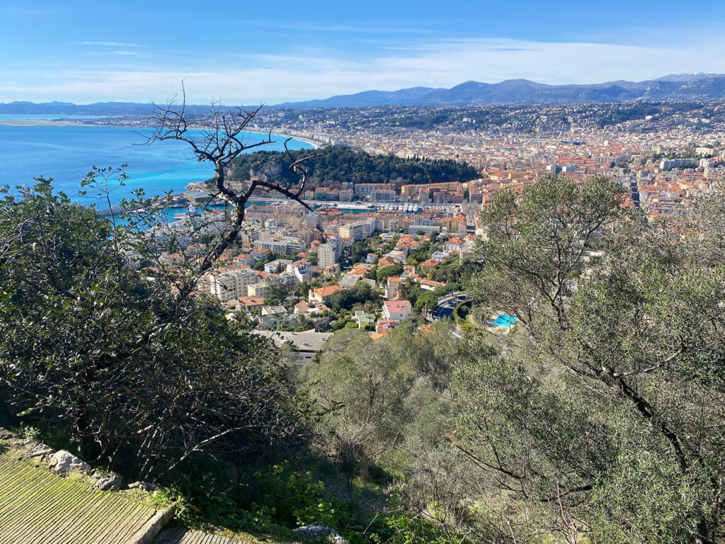
Fort du Mont Alban
High above the Bay of Nice, between Nice and Villefranche-sur-Mer, stands the Fort du Mont Alban – usually referred to simply as ‘Fort Alban’. This striking 16th-century fortress is not only an impressive example of early modern military architecture, but also a landmark that shapes the identity of the Côte d’Azur region.
Historical background
The fort was built in the 16th century under the rule of Emmanuel Philibert. At that time, Nice did not yet belong to France, but to the Duchy of Savoy. The aim of the construction was to secure the strategically important coastline against attacks, especially from the sea. Its exposed location at an altitude of around 220 metres allowed a wide view over the Bay of Nice and the port of Villefranche.
The massive, star-shaped structure with its thick walls and bastions was in line with the most modern defence principles of its time. Together with the citadel of Villefranche, the fort formed an effective defence system that could control both sea and land attacks.
Strategic importance
Its location between present-day Nice and Villefranche-sur-Mer made the fort a key point for regional security. From here, troops could detect movements along the coast at an early stage. Especially in an era when Mediterranean ports were of great importance for trade and the military, control of the sea routes was a decisive factor of power.
The fort retained its military relevance in later centuries. It continued to be used and adapted during various conflicts. Its solid construction has contributed to its good state of preservation to this day.
Significance for the surrounding area
Today, the fort no longer fulfils a military function, but is an important cultural and tourist attraction. It symbolises the region’s turbulent history – from Savoyard rule to integration into France and the modern development of the Côte d’Azur.
The fort is a popular destination for the inhabitants of Nice. The surrounding park offers walking trails with spectacular panoramic views of the Mediterranean, the foothills of the Alps and the coastal towns. Especially at sunset, the viewpoint is one of the most beautiful in the region.
The fort also contributes to the local identity: it is a reminder of the time when Nice was not yet French and illustrates the city’s historical role as a border and port city between different political powers.
Architecture and current condition
The compact, rectangular structure with its bastions is an example of Renaissance military architecture. Although the interior of the fort is not permanently open to the public, the complex can be viewed from the outside. The massive stone walls still convey an impression of the strategic importance of the building.
Conclusion
Fort Alban is much more than an old fortress. It is a historical testimony to power politics in the Mediterranean region, a symbol of regional identity and a viewpoint of exceptional beauty. Its presence above the Bay of Nice connects the past and the present – and highlights how closely history, landscape and urban development are intertwined on the Côte d’Azur.
in german:
Diese aussichtsreiche Wanderung an der Côte d’Azur verbindet Geschichte, Natur und spektakuläre Meerblicke. Auf relativ kurzer Strecke erlebst du mediterrane Vegetation, militärische Architektur und den Abstieg in eine der schönsten Buchten der Region.
Start: Col de Villefranche
Der Col de Villefranche liegt auf etwa 200 Metern Höhe zwischen Nizza und Villefranche-sur-Mer. Von hier aus führen mehrere gut ausgeschilderte Wege in Richtung Mont Alban. Schon nach wenigen Minuten öffnet sich der Blick auf die tiefblaue Rade de Villefranche und die Halbinsel Cap Ferrat.
Der Weg verläuft zunächst durch lichten Pinienwald. Der Duft von Aleppokiefern, Rosmarin und Thymian begleitet dich – typisch für die Garrigue-Vegetation der Region. Die Steigung ist moderat und gut machbar.
Etappe 1: Aufstieg zum Fort
Nach etwa 20–30 Minuten erreichst du das Fort du Mont Alban, eine Festung aus dem 16. Jahrhundert. Die massive Anlage thront auf rund 220 Metern Höhe und bietet eines der schönsten Panoramen der Côte d’Azur:
Blick westwärts über die Bucht von Nizza
Blick ostwärts über die Reede von Villefranche
Bei klarer Sicht: die schneebedeckten Seealpen im Hinterland
Eine Pause lohnt sich hier unbedingt. Rund um das Fort führen kleine Wege zu verschiedenen Aussichtspunkten.
Etappe 2: Abstieg Richtung Villefranche
Vom Fort aus nimmst du den Weg in Richtung Villefranche-sur-Mer. Der Pfad schlängelt sich in Serpentinen bergab durch mediterrane Vegetation. Immer wieder eröffnen sich neue Perspektiven auf die Bucht – das Farbspiel zwischen Ockerfassaden, türkisfarbenem Wasser und grünen Hügeln ist typisch für die Region.
Der Abstieg dauert etwa 40–60 Minuten, je nach Tempo und Fotostopps. Der Weg ist stellenweise steinig, daher sind feste Schuhe empfehlenswert.
Ziel: Villefranche-sur-Mer
Unten angekommen erreichst du die Altstadt von Villefranche-sur-Mer mit ihren engen Gassen und pastellfarbenen Häusern. Besonders sehenswert ist die historische Zitadelle Saint-Elme, die ebenfalls auf die militärische Bedeutung der Region verweist.
Am Hafen oder am Strand kannst du die Wanderung entspannt ausklingen lassen – vielleicht mit einem Kaffee oder einem Bad im Meer.
Praktische Hinweise
Dauer: ca. 1,5–2,5 Stunden (ohne lange Pausen)
Schwierigkeit: leicht bis mittel
Höhenunterschied: etwa 200 Meter
Beste Zeit: Frühjahr und Herbst (Sommer kann sehr heiß sein)
Ausrüstung: Wasser, Sonnenschutz, feste Schuhe
Fazit
Die Wanderung vom Col de Villefranche über das Fort Vauban (Mont Alban) nach Villefranche-sur-Mer ist ideal für alle, die eine kurze, aber eindrucksvolle Tour suchen. Sie verbindet Naturerlebnis mit Geschichte und bietet einige der schönsten Ausblicke an der französischen Mittelmeerküste.
Beschreibe mir bitte eine Wanderung vom Col de Villefranche über das Fort Vauban nach Villefranche und abschließender Besichtung des Fort von Villefranche mit Besichtigung der Galerien und Museen im Fort.
Wanderung vom Col de Villefranche über das Fort du Mont Alban nach Villefranche-sur-Mer mit Besichtigung der Citadelle Saint-Elme
Diese abwechslungsreiche Tour verbindet Natur, spektakuläre Ausblicke und eindrucksvolle Militärarchitektur – ein idealer Tagesausflug an der Côte d’Azur.
1. Start am Col de Villefranche
Der Col de Villefranche liegt auf etwa 200 Metern Höhe zwischen Nizza und Villefranche-sur-Mer. Vom Parkplatz bzw. der Straße aus führen mehrere Wege in Richtung Mont Alban. Schon nach wenigen Minuten eröffnen sich erste Blicke auf die tief eingeschnittene Bucht von Villefranche und das Cap Ferrat.
Der Weg steigt sanft an und führt durch lichten Pinienwald. Mediterrane Pflanzen wie Rosmarin, Thymian und Zwergpalmen säumen den Pfad. Der Anstieg ist moderat und gut begehbar.
Gehzeit bis zum Fort: ca. 20–30 Minuten
2. Aussichtspunkt Fort du Mont Alban (Fort Vauban)
Auf rund 220 Metern Höhe erreichst du das Fort du Mont Alban, eine Festung aus dem 16. Jahrhundert. Die Anlage wurde unter savoyischer Herrschaft erbaut und diente der Kontrolle der strategisch wichtigen Küste.
Von hier oben bietet sich ein spektakuläres Panorama:
Westwärts die Baie des Anges und Nizza
Ostwärts die Rade de Villefranche
Im Hintergrund die Seealpen
Die Aussicht gehört zu den schönsten der gesamten Region. Eine längere Pause lohnt sich, um die verschiedenen Blickwinkel rund um die Anlage zu genießen.
3. Abstieg nach Villefranche-sur-Mer
Vom Fort führt der Weg in Serpentinen bergab Richtung Villefranche. Der Pfad ist teils steinig, aber gut erkennbar. Während des Abstiegs wechseln sich Waldstücke mit offenen Aussichtspunkten ab, die immer neue Perspektiven auf das Meer eröffnen.
Mit zunehmender Nähe zum Ort erscheinen die ockerfarbenen Häuser und der kleine Hafen von Villefranche-sur-Mer. Der Abstieg dauert etwa 45–60 Minuten.
4. Ziel: Die Citadelle Saint-Elme in Villefranche
Am Hafen angekommen erreichst du die beeindruckende Citadelle Saint-Elme. Diese im 16. Jahrhundert errichtete Festung diente der Sicherung der Bucht und war Teil eines umfassenden Verteidigungssystems der Region.
Heute ist die Zitadelle kulturelles Zentrum der Stadt und beherbergt mehrere Museen und Ausstellungen:
Museen und Galerien in der Zitadelle
Musée Volti – Skulpturen des Künstlers Antoniucci Volti
Musée Goetz-Boumeester – Werke moderner Kunst
Sammlungen zur Stadtgeschichte – historische Dokumente und Modelle
Die Innenhöfe, Gewölbegänge und Bastionen können frei erkundet werden. Besonders eindrucksvoll sind die dicken Mauern und die Aussicht von den Bastionen auf die Bucht.
Besichtigungszeit: ca. 1–1,5 Stunden
5. Praktische Hinweise
Gesamtdauer (inkl. Besichtigung): ca. 3–4 Stunden
Höhenunterschied: ca. 200 Meter
Schwierigkeit: leicht bis mittel
Ausrüstung: feste Schuhe, Wasser, Sonnenschutz
Beste Jahreszeit: Frühjahr und Herbst (im Sommer sehr heiß)
Fazit
Diese Wanderung verbindet eindrucksvoll Natur, Geschichte und Kultur. Vom Panorama am Fort du Mont Alban bis zur atmosphärischen Besichtigung der Citadelle Saint-Elme erlebst du die strategische Bedeutung der Bucht von Villefranche aus nächster Nähe. Der Wechsel zwischen mediterraner Landschaft und historischer Architektur macht diese Tour zu einem der schönsten Halbtagesausflüge an der Côte d’Azur.
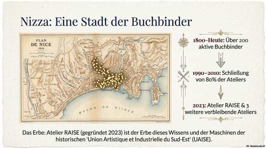
Das Atelier RAISE in Nizza, geführt von dem Experten Vincent Bottasso-Daideri, widmet sich der professionellen Buchbinderei und der Restaurierung historischer sowie moderner Werke. Die Quellen beschreiben ein breites Spektrum an Dienstleistungen, das von handwerklichen Fachkursen bis hin zur Gestaltung luxuriöser Künstlereditionen und humorvoller Kunstprojekte wie dem „Pass des Rosa Katzen-Landes“ reicht. Bottasso-Daideri ist zudem in der regionalen Kulturszene tief verwurzelt, unter anderem als Generalsekretär der Freunde des Kunstmuseums von Nizza und durch Kooperationen mit lokalen Künstlern wie Gérard Serée. Historische Rückblicke beleuchten die lange Tradition des Buchbinderhandwerks in der Region, während technische Erklärungen Einblicke in anspruchsvolle Verfahren wie die Vergoldung oder die Mosaik-Bindung geben. Das Atelier versteht sich somit als ein Zentrum für die Bewahrung des schriftlichen Kulturerbes und die Förderung zeitgenössischer Buchkunst.
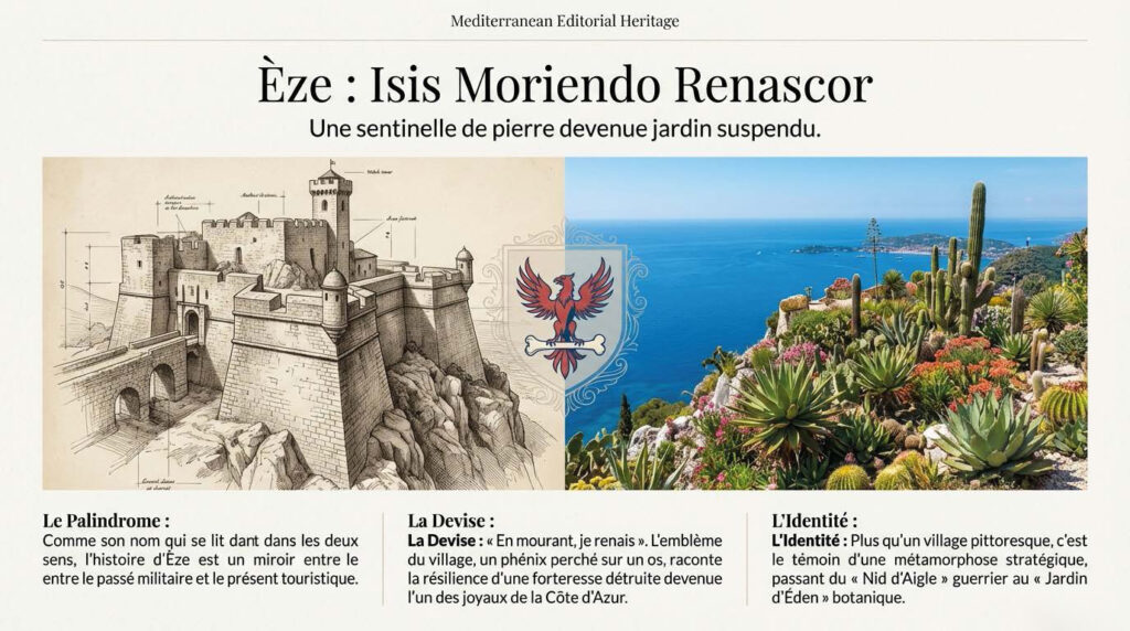
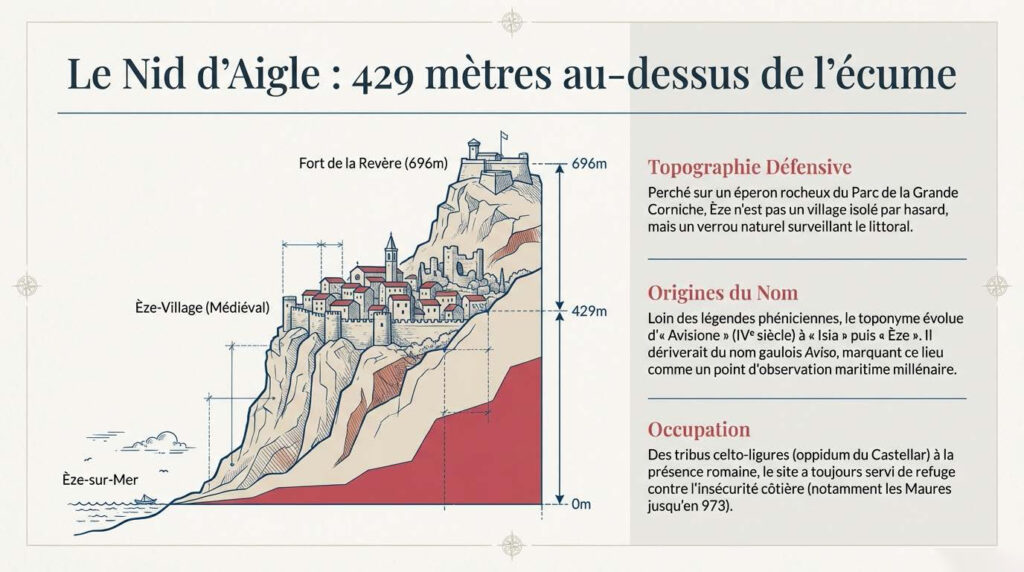
Between Nice and Monaco, the village of Èze rises like a defiant prayer in stone. Anyone climbing the steep path today can perhaps still sense the breath of centuries past—the crunch of boots on limestone, the distant thunder of cannons, the whispering of loyalties that changed with the wind like the flags on the battlements.
In the 14th and 15th centuries, this rocky nest belonged to the Duchy of Savoy, that idiosyncratic power between the Alps and the sea, which was neither entirely Italian nor entirely French, but a border kingdom – tough, ambitious, distrustful. Savoy knew the value of heights. Whoever held the mountains held the roads. And whoever held the roads controlled trade, customs duties, rumors – and destiny.
Èze was not a pretty village for painters and flâneurs, but a guard post. Fortification – Savoy’s systematic policy of fortification – turned the rock into a bastion. Rings of walls snaked around the summit like stone serpents; narrow gates, built so that no assault could easily break them, forced attackers into tight angles. A keep rose above the roofs, watchful like a stone eye over the Mediterranean. The houses themselves were part of the defense: densely built, with hardly any gaps, narrow alleys that resembled embrasures rather than streets. Those who fought here fought step by step.
Savoy fortified not out of vanity, but out of necessity. The coast was contested. The Counts of Provence looked covetously upon the strategic heights. Later, the French crown pressed in, and from the east, the influence of the Italian powers grew. Èze was a border post in a game whose rules were constantly changing.
The fighting rarely took the form of large, decisive battles. It came in the form of dawn raids, sieges that lasted for weeks, and betrayals behind half-open gates. According to chronicles from the region, a Savoyard garrison once held out for months while enemy troops cut off the water supply. They lived on supplies, salted fish, and whatever the cisterns yielded. Thirst was the invisible besieger.
But Savoy knew how to hold its ground. The dukes – from Amadeus to their successors – invested in stone rather than splendor. While cathedrals grew elsewhere, bastions grew here. The walls of Èze were reinforced, towers raised, embrasures adapted to the new art of gunpowder. With the advent of artillery, the rock also changed: the ramparts had to be lower, thicker, and more resistant. War wrote its technical evolution into the limestone.
And yet the village was more than just a garrison. Between the alarm calls, everyday life revolved around olive oil, fishing, and pious processions. The people knew that they were living on a threshold. Their identity was not a fixed banner, but a fabric of dialects, alliances, and survival strategies. Sometimes they spoke of the Savoyard lord with loyalty, sometimes with cautious distance. For power, they had learned, is never final in border regions.
In the 16th century, when the great European conflicts reached the coast, Èze once again became a pawn. Tensions between Savoy and France escalated, and the region around Nice was fought over several times. The walls of Èze saw banners change, heard commands in different languages. Each party promised protection; each demanded loyalty.
It is said that after a particularly fierce battle, parts of the fortifications were severely damaged. But even in ruins, the place remained a symbol. The rock itself was the real fortress – ancient, unyielding, indifferent to the changing rulers. Savoy may have ruled, France may have pressed, but the stone outlasted them all.
When you walk through Èze today, between galleries and gardens, you can only see fragments of that defensibility. But in the narrowness of the alleys, in the abrupt drop of the cliffs, in the view down to the wide sea, that old logic still remains: whoever stands up here has gained time.
And perhaps that is the real story of Savoy in Èze—not triumph or defeat, but the steadfast holding of a rock against the turmoil of the world.
in Deutsch:
Zwischen Nizza und Monaco erhebt sich, wie ein trotziges Gebet aus Stein, das Dorf Èze. Wer heute den steilen Pfad hinaufsteigt, ahnt vielleicht noch den Atem der Jahrhunderte – das Knirschen von Stiefeln auf Kalk, das ferne Donnern von Geschützen, das Flüstern von Loyalitäten, die im Wind wechselten wie die Fahnen auf den Zinnen.
Im 14. und 15. Jahrhundert gehörte dieses felsige Nest zur Herzogtum Savoyen, jener eigenwilligen Macht zwischen Alpen und Meer, die weder ganz italienisch noch ganz französisch war, sondern ein Grenzreich – zäh, ehrgeizig, misstrauisch. Savoyen wusste um den Wert von Höhen. Wer die Berge hielt, hielt die Wege. Und wer die Wege hielt, kontrollierte den Handel, die Zölle, die Gerüchte – und das Schicksal.
Èze war kein schmuckes Dorf für Maler und Flaneure, sondern eine Wache. Die Fortesierung – jene systematische Befestigungspolitik Savoyens – machte aus dem Felsen eine Bastion. Mauerringe schlangen sich um den Gipfel wie steinerne Schlangen; schmale Tore, so gebaut, dass kein Sturmangriff sie leicht brechen konnte, zwangen Angreifer in enge Winkel. Ein Donjon erhob sich über die Dächer, wachsam wie ein steinernes Auge über dem Mittelmeer. Die Häuser selbst waren Teil der Verteidigung: dicht gebaut, kaum Zwischenräume, schmale Gassen, die eher Scharten als Straßen glichen. Wer hier kämpfte, kämpfte Schritt um Schritt.
Savoyen befestigte nicht aus Eitelkeit, sondern aus Not. Die Küste war umkämpft. Die Grafen von Provence blickten mit Begehrlichkeit auf die strategischen Höhen. Später drängte die französische Krone, und von Osten her wuchs der Einfluss der italienischen Mächte. Èze war Grenzposten in einem Spiel, dessen Regeln sich ständig änderten.
Die Kämpfe kamen selten als große, entscheidende Schlacht. Sie kamen als Überfälle im Morgengrauen, als Belagerungen, die Wochen dauerten, als Verrat hinter halb geöffneten Toren. Einmal – so berichten Chroniken aus der Region – soll eine savoyische Garnison monatelang ausgeharrt haben, während feindliche Truppen die Wasserzufuhr kappten. Man lebte von Vorräten, von gesalzenem Fisch, von dem, was die Zisternen hergaben. Der Durst war der unsichtbare Belagerer.
Doch Savoyen verstand es, seine Höhen zu halten. Die Herzöge – von Amadeus bis zu ihren Nachfolgern – investierten in Stein statt in Pracht. Während anderswo Kathedralen wuchsen, wuchsen hier Bastionen. Die Mauern von Èze wurden verstärkt, Türme erhöht, Schießscharten an die neue Kunst des Pulvers angepasst. Mit dem Aufkommen der Artillerie veränderte sich auch der Fels: niedriger, dicker, widerstandsfähiger mussten die Wälle sein. Der Krieg schrieb seine technische Evolution in den Kalkstein.
Und doch war das Dorf mehr als Garnison. Zwischen den Alarmrufen lebte ein Alltag aus Olivenöl, Fischfang und frommen Prozessionen. Die Menschen wussten, dass sie auf einer Schwelle lebten. Ihre Identität war kein festes Banner, sondern ein Gewebe aus Dialekten, Bündnissen, Überlebensstrategien. Mal sprach man vom savoyischen Herrn mit Loyalität, mal mit vorsichtiger Distanz. Denn Macht, das hatte man gelernt, ist in Grenzregionen nie endgültig.
Im 16. Jahrhundert, als die großen europäischen Konflikte die Küste erreichten, wurde Èze erneut zum Spielball. Die Spannungen zwischen Savoyen und Frankreich eskalierten, und die Region um Nizza wurde mehrfach umkämpft. Die Mauern von Èze sahen Banner wechseln, hörten Befehle in verschiedenen Zungen. Jede Partei versprach Schutz; jede forderte Treue.
Es heißt, dass nach einem besonders heftigen Gefecht Teile der Befestigung schwer beschädigt wurden. Doch selbst in Trümmern blieb der Ort Symbol. Der Fels selbst war die eigentliche Festung – uralt, unbeugsam, gleichgültig gegenüber den wechselnden Herren. Savoyen mochte herrschen, Frankreich mochte drängen, doch der Stein überdauerte sie alle.
Wenn man heute durch Èze geht, zwischen Galerien und Gärten, sieht man nur noch Fragmente jener Wehrhaftigkeit. Doch in der Enge der Gassen, im abrupten Abbruch der Klippen, im Blick hinunter auf das weite Meer liegt noch immer jene alte Logik: Wer hier oben steht, hat Zeit gewonnen.
Und vielleicht ist das die eigentliche Geschichte Savoyens in Èze – nicht Triumph oder Niederlage, sondern das beharrliche Halten eines Felsens gegen die Unruhe der Welt.
We did this full-day train experience through the Alps from Nice, and it completely surprised us in the best way. We met early in the morning at the main train station, grabbed a quick coffee, and then boarded the mountain train that slowly climbed into the Alps. The ride itself was incredible, winding through narrow canyons, tunnels, and over high viaducts, with nonstop views of valleys, rivers, and tiny villages tucked into the mountains. Our guide shared stories and pointed out details along the way, which made the journey even more interesting and helped us understand what we were seeing instead of just passing through it.
Once we reached the Roya Valley, we started exploring a couple of medieval villages, including Saorge and Tende. Walking through the narrow stone streets, small squares, and quiet corners felt like stepping into another time. We visited old churches, took in sweeping mountain views, and even did a short hike that led to some really peaceful spots overlooking the valley. Lunch was simple and relaxed, with local food that tasted even better after a morning of walking and fresh mountain air. Everything was well-paced, and there was a nice balance between exploring, learning, and just enjoying the scenery.
What stood out most was how different this day felt compared to the busy coastal towns. It was calm, scenic, and refreshing, and the logistics were completely taken care of, which made it easy to just enjoy the experience. Planning this kind of route on our own with trains, buses, and village connections would have been complicated, so having a guide and a clear plan made a huge difference. If you want a break from the Riviera crowds and love scenic train rides, mountain views, and quiet villages, this is such a memorable way to spend a day.